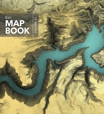
Esri Map Book, Volume 31
Environmental Systems Research Institute Inc.,U.S. (Verlag)
978-1-58948-468-9 (ISBN)
- Titel ist leider vergriffen;
keine Neuauflage - Artikel merken
Every year, works of mapmakers from around the world are selected for the Esri Map Book to demonstrate how geographic information system (GIS) technology helps our governments, businesses, and citizens. Esri Map Book, Volume 31, continues this tradition, showcasing maps and applications that use ArcGIS to evaluate the sustainability of resources, determine efficient transportation routes, mitigate the effects of natural disasters, and much more. Each map or application incudes a description of its purpose and how it was produced. Esri Map Book, Volume 31 is an important collection of maps for GIS users, cartographers, collectors, and map libraries.
Map authors from organizations around the world were selected to contribute to this Esri map book. The maps are chosen from submissions displayed at the 2015 Esri International User Conference and other sources. Contributors come from various industries such as conservation, government, natural resources, sustainable development, tourism, and utilities.
BUSINESS
World Consumer Styles
Using Kriging Geostatistical Analysis in Property Valuation
Residential Housing Analysis - Effective Year Built
US 75 Corridor—Retail Trade Analysis 2002-2014
CARTOGRAPHY
Grand Canyon National Park
Flaming Gorge Reservoir Illuminated with an Overcast Sky
New National Map 1:25,000 for Switzerland
Swiss Aeronautical Chart ICAO 1:500,000
Rush Hour in Tokyo
Conservation Outcomes: Madagascar and the Indian Ocean Islands
CONSERVATION AND SUSTAINABLE DEVELOPMENT
Tejon Ranch
GIS Techniques Used For Stream Mapping & Restoration
Modeling Cougar Corridors in Owens Valley
Spatial Priorities for Habitat Connectivity in the Berkshire Wildlife Linkage
Greater Sage Grouse Habitat
Predicting Swamp Rabbit Habitat in Southeast Missouri
Ice-associated seal surveys in the eastern Bering Sea
DEFENSE AND MILITARY
Fort Hunter Liggett Net Zero
Impact of Snow Depth on Truck Mobility in Afghanistan: February 2013
EDUCATION
GIS Education at Work
Location-based Predictive Analytics in K-12 Facility Planning
ENVIRONMENTAL MANAGEMENT
Utilization of High Temporal Frequency Unmanned Aerial System Imagery in GIS
Trivariate Sea Ice Presence
Polar Bear Population Status and Trends
Estimate of future carbon budget in the Korean peninsula
Fire Progressions - North Rim of Grand Canyon National Park
GOVERNMENT-LAW ENFORCEMENT
A Three Part Suitability Analysis for Cobb County, GA:
GOVERNMENT-PUBLIC SAFETY
City of Scottsdale Fire Headquarters Maps
Coal Creek Floodplain Mapping and Coal Creek Flood Hazard Management Zones
Mount Morris Dam Failure HAZUS Simulation within Monroe County NY
City of Boston Hurricane Evacuation Zone Development
Historical Collision Patterns in Southern California
Sea-level rise vulnerability mapping of South Florida
City of Scottsdale Emergency Operations Center (EOC) Maps
The Fairfax County Fire & Rescue Department's ArcGIS Online Website
Statewide Haz-Mat Teams Response Time
GOVERNMENT-STATE AND LOCAL
Walkability - City of Manhattan, KS
A Bright Idea
A "30,000" Foot Overview of LiDAR
Richmond Gentrification Analysis
Interactive Kirkland Maps
Santa Clara County Diversity
Interpolating ACS Data Using an Adaptive Bandwidth Grid
3D map of Rio's Favelas - Borel's Case Study
Mayor's Poverty Reduction Initiative Priority Area - Census Tract 10.01
Single Family Residential Housing Changes - City of Houston
HEALTH AND HUMAN SERVICES
Network analysis for access to drinking establishments in the United States, 2013
Evaluating Malaria Treatment Accessibility in Western Kenyan Highlands
HISTORICAL AND CULTURAL
Happiness Map of Japan: Geographical Differences in Internet Slang for Laughing and Emoticons of Smiling Faces in Japanesel
Hotspots of Tweets related to food, entertainment, work and study in Gangnam area of Seoul, Korea
HUMANITARIAN AFFAIRS
The Syrian Conflict and Migration of Refugees
NATURAL RESOURCES-AGRICULTURE
Crop Planting Frequency Data Layers (2008 - 2014) for Corn, Cotton, Soybeans, and Wheat
A National Relative Index for Potential Water and Wind Erosion
Groundwater Vulnerability in Wheat-Growing Regions of the United States
NATURAL RESOURCES-FORESTRY
Central and coastal Alaska
Existing Vegetation Mapping on the Caribou-Targhee National Forest
Zambia - Change Detection
Firecast: A Near-Real Time Monitoring System Improving Forest Management in the Tropics
Severity Trends for Western U.S. Wildfires - 1984-2012
NATURAL RESOURCES-MINING AND EARTH SCIENCES
Ground subsidence hazard map of underground coal mine area in Samcheok, South Korea
Pathway and Tendency of Heavy Metal Releases from Tailings of the Abandoned Mine in South Korea
What Lies Beneath: Spatial Trend Analysis to Reduce Subsurface Uncertainty in the Gulf of Mexico
Global Hurricane Tracks
NATURAL RESOURCES-WATER
NEXRAD Rainfall Comparative Study
Assessment of Enhanced Aquifer Recharge Potential - Twin Cities Metro Area
Mapping Stormwater Plume in Southern California’s Marine Protected Areas
Drought, Drops and Dots - Declining Groundwater Levels across California
Groundwater Particle Tracking: Using GIS to Calculate the Path of Groundwater Contamination
Napa Quake 2014 & Primary Water Release
PLANNING AND ENGINEERING
Siting Fire Units
United States Army Corps of Engineers - Civil Works Projects
City of Monrovia: Planning for New Development Using ESRI's ArcGIS and City Engine
Offshore wind energy, the Netherlands
McCarran International Airport-Airfield Lighting Decoded
TOURISM AND RECREATION
Taking a Ride on the C&T
Wasatch Back Ski Resorts - Utah
Mountain Goat Trail
Pizza Corridors of New York City
Maryland Appalachian Trail Shelter Site Assessment
Parks of Kenton County (Northern Kentucky MapLAB)
Walkability: Sidewalk Connectivity in Kenton County (Northern Kentucky MapLAB)
TRANSPORTATION
Transit Ridership by Corridor
Using GIS to Support In-Flight Operations in the Event of an Airport Outage
Vermont Route Logs: Python-driven Map Automation with Straight Line Diagrams
Spatiotemporal Analysis of Traffic Collisions in Lakewood, CA
UTILITIES-ELECTRIC AND GAS
IEC Electric Distribution ArcFM Map
Addison Natural Gas Project Natural Resource Map
UTILITIES-WATER AND WASTEWATER
14-Year Groundwater Level Change
2014 Groundwater Elevation
2014 Depth to Groundwater
Novato Storm Drainage Master Plan with ArcSDE
2014 Water Main Failure Analysis, Erie, PA
WRD District Map with Water Independence Now (WIN) Projects
Measuring Sandy Impact & Recovery through Water Consumption -- Esri
| Erscheinungsdatum | 17.08.2016 |
|---|---|
| Reihe/Serie | Esri Map Book |
| Zusatzinfo | 190 Maps |
| Verlagsort | Redlands |
| Sprache | englisch |
| Maße | 254 x 279 mm |
| Themenwelt | Reisen ► Karten / Stadtpläne / Atlanten ► Welt / Arktis / Antarktis |
| Naturwissenschaften ► Geowissenschaften ► Geografie / Kartografie | |
| ISBN-10 | 1-58948-468-1 / 1589484681 |
| ISBN-13 | 978-1-58948-468-9 / 9781589484689 |
| Zustand | Neuware |
| Informationen gemäß Produktsicherheitsverordnung (GPSR) | |
| Haben Sie eine Frage zum Produkt? |
aus dem Bereich


