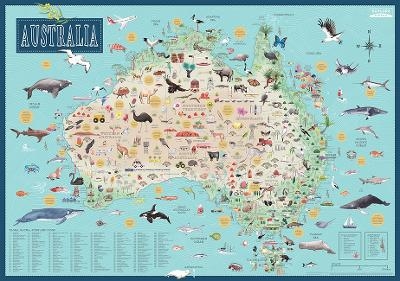
Australia: Illustrated Map
Seiten
2017
|
Maps
Hardie Grant Explore (Verlag)
978-1-74117-557-8 (ISBN)
Hardie Grant Explore (Verlag)
978-1-74117-557-8 (ISBN)
- Titel ist leider vergriffen;
keine Neuauflage - Artikel merken
Wall maps are one of the latest trends when it comes to interior decorating, and now both adults and kids alike can adorn their walls with this beautifully illustrated map of Australia. Showcasing more than 300 illustrations of flora, fauna, landmarks, attractions and other Australiana, the detail on this map could keep anyone enthralled for hours. Fact bubbles, and keys for shipwrecks and Indigenous rock-art sites, will also help you learn more about the country. The map is printed on laminated, tearproof, writable and washable high-quality art paper. They are individually packaged in a nicely designed tube.
Tania McCartney is an experienced Australian author, illustrator and editor. She has authored several picture books, non-fiction and junior fiction titles, and has received various awards. Her first self-illustrated book, Australia Illustrated, was released in November 2016.
| Erscheinungsdatum | 31.01.2018 |
|---|---|
| Sprache | englisch |
| Maße | 950 x 1350 mm |
| Themenwelt | Reisen ► Karten / Stadtpläne / Atlanten ► Australien / Neuseeland / Ozeanien |
| Kinder- / Jugendbuch ► Sachbücher ► Allgemeines / Lexika | |
| Schulbuch / Wörterbuch | |
| ISBN-10 | 1-74117-557-7 / 1741175577 |
| ISBN-13 | 978-1-74117-557-8 / 9781741175578 |
| Zustand | Neuware |
| Informationen gemäß Produktsicherheitsverordnung (GPSR) | |
| Haben Sie eine Frage zum Produkt? |
Mehr entdecken
aus dem Bereich
aus dem Bereich
Unser Planet in Karten, Fakten und Bildern
Buch | Hardcover (2021)
Bibliographisches Institut (Verlag)
CHF 69,90

