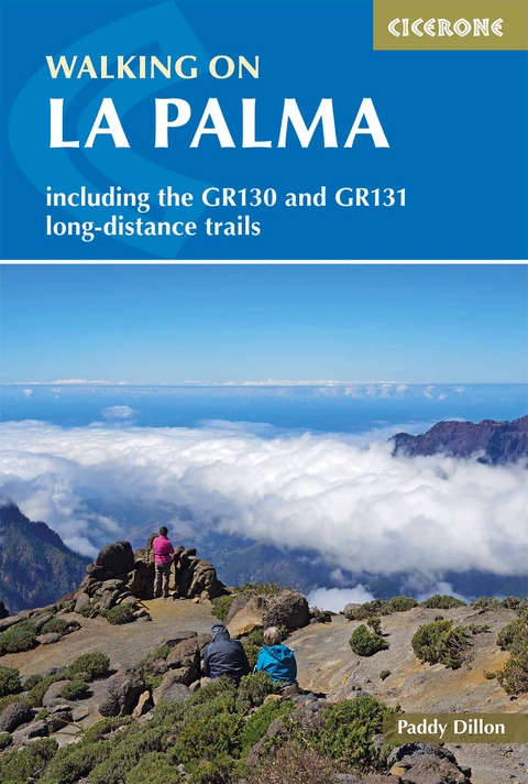
Walking on La Palma
Cicerone Press (Verlag)
978-1-85284-853-8 (ISBN)
A guidebook to day walks and treks on La Palma. Exploring the beautiful scenery of this Canary Island, the walks are suitable for beginner and experienced walkers alike.
The 34 day walks range from 6 to 32km (4–20 miles) and can be enjoyed in 2–10 hours. The GR131 trek crosses all seven of the Canary Islands, and the La Palma section is described in 3 stages covering 68km (42 miles). The GR130, a circular long-distance walk around La Palma, is also included, covering 167km (104 miles) over 8 stages.
1:50,000 maps included for each walk
Detailed information on planning, facilities and public transport
Highlights include Caldera de Taburiente national park
Part of a 5-volume Cicerone series on the whole of the Canary Islands
Paddy Dillon is a prolific outdoor writer with over 90 guidebooks to his name, and contributions to 40 other publications. He has written for a variety of outdoor magazines, as well as many booklets and brochures for tourism organisations. Paddy lives near the Lake District and has walked in every county in England, Scotland, Ireland and Wales; writing about walks in every one of them. He enjoys simple day walks, challenging long-distance walks, and is a dedicated island-hopper. He has led guided walks and walked extensively in Europe, as well as in Nepal, Tibet, Korea, Africa and the Rocky Mountains of Canada and the United States.
Map key
Overview maps
Introduction
Location
Geology
Wildlife
National parks
The Fortunate Isles
Getting there
When to go
Accommodation
Health and safety
Food and drink
Language
Money
Communications
Walking on La Palma
Getting there
Getting around
What to take
Waymarking and access
Maps
Food and drink
Tourist information offices
Emergencies
Using this guide
The Walks
1 Santa Cruz and Lomo de las Nieves
2 Fuentes de Las Breñas
3 Buenavista and Pico de las Ovejas
4 Santa Cruz and Montaña de Tagoja
5 Pico de la Nieve to Santa Cruz
6 Santa Cruz to Puerto de Tazacorte
7 El Paso to Refugio del Pilar
8 Refugio del Pilar to Santa Cruz
9 Refugio del Pilar to Playa del Hoyo
10 Refugio del Pilar to Playa del Hoyo or La Salemera
11 Refugio del Pilar and Pico Nambroque
12 Jedey to Tigalate
13 San Nicol&##xe1;s and Coladas de San Juan
14 Llanos del Jable and Coladas de San Juan
Caldera de Taburiente
15 Pico Bejenado
16 La Cumbrecita to La Cancelita and Los Llanos
17 Barranco de las Angustias and Caldera de Taburiente
18 La Cumbrecita to Caldera de Taburiente
19 Caldera de Taburiente and Hoya Verde
20 Tijarafe and Porís de Candelaria
21 Tinizara to Piedras Altas and Tijarafe
22 La Traviesa: El Time to Briesta
23 La Traviesa: Briesta to Barlovento
24 La Zarza and Don Pedro
25 Roque del Faro to Garafía
26 Roque del Faro and Franceses
27 Roque del Faro to Roque de los Muchachos
28 Roque de los Muchachos to Puntagorda or Tijarafe
29 Pico de la Cruz to Barlovento
30 Pico de la Cruz to Los Sauces or Barlovento
31 Los Sauces and Los Tilos
32 Fuente de Ol&##xe9;n to Las Lomadas
33 Fuente Vizcaína to La Galga
34 Pico de la Nieve to Puntallana or Tenagua
35 GR 130: Santa Cruz de La Palma to Mazo
36 GR 130: Mazo to Fuencaliente
37 GR 130: Fuencaliente to Los Llanos
38 GR 130: Los Llanos to Puntagorda
39 GR 130: Puntagorda to Garafía
40 GR 130: Garafía to Franceses
41 GR 130: Franceses to Los Sauces
42 GR 130: Los Sauces to Santa Cruz de La Palma
43 GR 131: Puerto de Tazacorte to Roque de los Muchachos
44 GR 131: Roque de los Muchachos to Refugio del Pilar
45 GR 131: Refugio del Pilar to Faro de Fuencaliente
Appendix A Route summary table
Appendix B Topographical glossary
Appendix C Useful contacts
| Erscheinungsdatum | 14.01.2019 |
|---|---|
| Reihe/Serie | Cicerone guidebooks |
| Zusatzinfo | 100 colour photos and 75 colour maps |
| Verlagsort | Kendal |
| Sprache | englisch |
| Maße | 116 x 172 mm |
| Gewicht | 270 g |
| Themenwelt | Sachbuch/Ratgeber ► Sport |
| Reiseführer ► Europa ► Spanien | |
| Reisen ► Reiseführer ► Welt / Arktis / Antarktis | |
| Reisen ► Sport- / Aktivreisen ► Europa | |
| ISBN-10 | 1-85284-853-7 / 1852848537 |
| ISBN-13 | 978-1-85284-853-8 / 9781852848538 |
| Zustand | Neuware |
| Informationen gemäß Produktsicherheitsverordnung (GPSR) | |
| Haben Sie eine Frage zum Produkt? |
aus dem Bereich


