Africa
1996
|
Revised edition
Collins (Verlag)
978-0-7028-3550-6 (ISBN)
Collins (Verlag)
978-0-7028-3550-6 (ISBN)
- Titel ist leider vergriffen;
keine Neuauflage - Artikel merken
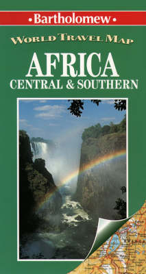
This physical map extends from Lake Turkana four degrees north of the equator, to the Cape of Good Hope on the southwestern tip of Cape Provence. A detailed road and rail network is shown with international and administrative boundaries as a background. An inset map of Madagascar is also included.
| Erscheint lt. Verlag | 12.9.1996 |
|---|---|
| Reihe/Serie | Bartholomew World Travel Map S. |
| Verlagsort | London |
| Sprache | englisch |
| Maße | 143 x 259 mm |
| Gewicht | 90 g |
| Themenwelt | Reisen ► Karten / Stadtpläne / Atlanten ► Afrika |
| ISBN-10 | 0-7028-3550-1 / 0702835501 |
| ISBN-13 | 978-0-7028-3550-6 / 9780702835506 |
| Zustand | Neuware |
| Haben Sie eine Frage zum Produkt? |
Mehr entdecken
aus dem Bereich
aus dem Bereich
Karte (gefalzt) (2024)
Freytag-Berndt und ARTARIA (Verlag)
CHF 18,95
Karte (gefalzt) (2023)
Freytag-Berndt und ARTARIA (Verlag)
CHF 21,90
reiß- und wasserfest (world mapping project)
Karte (gefalzt) (2024)
Reise Know-How (Verlag)
CHF 17,90


