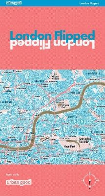
London Flipped
Seiten
2024
Urban Good (Verlag)
978-1-914432-17-0 (ISBN)
Urban Good (Verlag)
978-1-914432-17-0 (ISBN)
The first full size map of London, drawn upside-down!
This is not a cartographic revolution, its simply a rotation! Something to keep the topsy-turvy happy and give a fresh twist on a familiar view.
The first full-size map of London drawn upside-down - this map surprises even those most familiar with the capital's cartography.
It is a true, topographical map covering the whole of Greater London and its surroundings, but rotated 180 Degrees. With south at the top and north at the bottom, this map challenges conventional perspectives and helps people re-imagine London without the perverse and pervasive bias of north-up.
The underground and overground rail networks help situate the map-reader spectacularly. Parks, woods, and open spaces form novel geometries that reawaken. Three recognisable London edges are imposed, and the water has turned gold!
Printed in the same format as Ordnace Survey Explorer maps, over a meter wide, this paper map will look great on a wall or in the readers hands.
Every station is marked and labeled along with hundreds of the key parks, woods and open spaces across the city. The waterways, lakes and ponds are drawn in gold.
A great gift for anyone London-curious.
Urban Good CIC was established by Charlie Peel in 2016 as a social enterprise. The maps have inspired millions to see their cities in a new light, and explore in a different way. Several months are spent researching and drawing the maps to add something valuable, beautiful and unique to the travel-map offer.
| Erscheint lt. Verlag | 9.7.2024 |
|---|---|
| Sprache | englisch |
| Maße | 133 x 240 mm |
| Gewicht | 120 g |
| Themenwelt | Reisen ► Karten / Stadtpläne / Atlanten ► Welt / Arktis / Antarktis |
| ISBN-10 | 1-914432-17-7 / 1914432177 |
| ISBN-13 | 978-1-914432-17-0 / 9781914432170 |
| Zustand | Neuware |
| Haben Sie eine Frage zum Produkt? |
Mehr entdecken
aus dem Bereich
aus dem Bereich
1:30 Mio. mit Posterleisten, mit Oberflächenlaminat
Karte (gerollt) (2023)
INTERKART Landkarten & Globen (Verlag)
CHF 32,90


