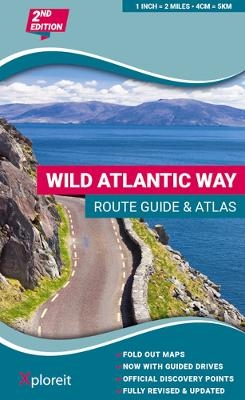
Wild Atlantic Way Route Guide and Atlas
Xploreit Maps (Verlag)
978-0-9552655-9-4 (ISBN)
31 handy fold-out maps.
16 easy-to-follow drives.
Official Discovery Points highlighted.
Additional recommendations and tips.
Route planning maps for the national road network.
Distance charts for towns and villages.
Yvonne Gordon is an award-winning travel writer who writes about Ireland for publications around the globe including the Irish Independent, The Guardian, Lonely Planet, The Washington Post, National Geographic Travel, BBC Travel and Hemispheres magazine. She is the author of Frommer's Ireland, co-author of Back Roads Ireland and Lonely Planet Experience Ireland and her awards include Irish Travel Writer of the Year. Based in Dublin, she explores the Wild Atlantic Way regularly, finding something new and fascinating on each journey.
Route Maps Overview 2
Contents 3
Introduction 4
The Wild Atlantic Way 5
Drive 1 - Kinsale to Baltimore8
Drive 2 - Baltimore to Bantry 12
Drive 3 - Bantry to Kenmare 16
Drive 4 - Kenmare to Killorglin 20
Drive 5 - Killorglin to Tralee 24
Drive 6 - Tralee to Killimer/Kilrush 28
Drive 7 - Killimer/Kilrush to Doolin 32
Drive 8 - Doolin to Galway 36
Drive 9 - Galway to Clifden 40
Drive 10 - Clifden to Westport 44
Drive 11 - Westport to Belmullet 48
Drive 12 - Belmullet to Sligo 52
Drive 13 - Sligo to Ardara 56
Drive 14 - Ardara to Dunfanaghy 60
Drive 15 - Dunfanaghy to Buncrana 64
Drive 16 - Buncrana to Muff 68
Legend 72
Start from Kinsale / Start from Muff M1
West Cork and Mizen Head M2
Old Head of Kinsale M3
Dursey Island M4
The Beara Peninsula M5
Valentia and The Skellig Islands M6
The Iveragh Peninsula M7
Slea Head and The Blasket Islands M8
The Dingle Peninsula M9
The Shannon Estuary M10
The River Shannon M11
Loop Head Peninsula M12
The Cliffs of Moher M13
The Aran Islands M14
The Burren M15
Ceantar na nOilean and Slyne Head M16
Galway Bay M17
Connemara M18
Clew Bay M19
Nephin Beg and Achill Island M20
The Mullet Peninsula M21
Downpatrick Head and Killala Bay M22
Sligo Bay M23
Donegal Bay M24
Slieve League M25
Arranmore and The Rosses M26
Tory Sound M27
Fanad Head and Lough Swilly M28
Malin Head M29
Route Planning - North M30
Route Planning - South M31
Index I32
| Erscheinungsdatum | 16.05.2023 |
|---|---|
| Verlagsort | Ennis |
| Sprache | englisch |
| Maße | 167 x 210 mm |
| Themenwelt | Reisen ► Sport- / Aktivreisen ► Europa |
| ISBN-10 | 0-9552655-9-2 / 0955265592 |
| ISBN-13 | 978-0-9552655-9-4 / 9780955265594 |
| Zustand | Neuware |
| Haben Sie eine Frage zum Produkt? |
aus dem Bereich


