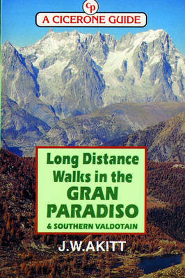
Long Distance Walks in the Gran Paradiso
Cicerone Press (Verlag)
978-1-85284-247-5 (ISBN)
- Titel ist leider vergriffen;
keine Neuauflage - Artikel merken
The Gran Paradiso is well known to continental walkers, but it is unusual to encounter any British walkers there. This guide has been written to show what is possible. An in-depth introduction describes many facets of the Valdotain hill country and deals with the differences likely to be found between walking in the UK and the Alps. The Via Alta 2 is a walk within the reach of any strong walker, covering 88 miles and 9000m of ascent, passing from valley to valley over high cols. The Via Alta 4 is more demanding undertaking over 106 miles with 9000m of ascent. Like the Via Alta 2, this passes from valley to valley but more into the heart of the mountains and close to the glaciers. The Traverse of the Gran Paradiso is described, though only the western portion of the route is given, which is also within the abilities of any strong walker. It passes through some very wild country, with little accommodation so that the walker has to be self contained. Finally, some shorter outings are described.
I have spent the major part of my life in the North of England, working both in Industry and the University sector. In 1979 my wife and I bought an apartment at Bourg St Maurice for the skiing and soon found that the region around had considerable attraction for walking in summer. As it is just to the south of Mt Blanc, the big mountain has taken all the attention and the Tarentaise has been rather ignored by the Brits. There are many walks of good quality in beautiful places, well documented in the French guides but with often a lack of information on how to get to the start of the walks. We therefore investigated the area in depth and built up a mass of knowledge which I have been able to pass on in the form of the Tarentaise guide. It was a natural step to cross the frontier into Italy and follow the Via Alta, whence the Grand Paradiso guide. The whole of the Graian Alps is very beautiful and days spent in these hills are always highly rewarding, to come back to again and again, and indeed, we now live here permanently to enjoy the views and the marvellous flora.
INTRODUCTION Access and accommodation Tourist offices, cheaper hotels or albergi, campsites When to go The weather Maps and books Language Glossary of equivalent French/Italian/English terms found on maps Footpaths and waymarking Grading of walks and time required Walking strategy Security Refuges and bivouacs Some general information Geology Flora Fauna The Gran Paradiso National Park Food and drink Using the telephone in Italy THE LONG DISTANCE WALKS Introduction THE VIA ALTA 2 Stage 1. Courmayeur to La Thuile Stage 2. La Thuile to Valgrisenche Stage 3. Valgrisenche to Rhemes Notre Dame Stage 4. Rhemes Notre Dame to Eaux Rousses Stage 5. Eaux Rousses to Cogne Stage 6. Cogne to Chateau Champorcher THE VIA ALTA 4 Stage 1. Champorcher to Cogne Stage 2. Cogne to Pont Stage 3. Pont to Rifugio Benevolo Stage 4. Rifugio Benevolo to Rifugio Bezzi Stage 5. Rifugio Bezzi to La Thuile Stage 6. La Thuile to Courmayeur THE GRAND TRAVERSE OF THE GRAN PARADISO Stage 1. Valgrisenche to Rifugio Benevolo Stage 2. Rifugio Benevolo to the Col del Nivolet Stage 3. Col del Nivolet to Rifugio Pocchiolo Menenghello Section 1. Col del Nivolet to Bivouac Margherita Giraudo Section 2. Bivouac Giraudo to Bivouac Ivrea Section 3. Bivouac Ivrea to Rifugio Pontese Section 4. Rifugio Pontese to Rifugio Pocchiolo Meneghello Descent routes to the valley Descent 1. Bivouac Giraudo to Ceresole Reale Descent 2. Rifugio Pontese to Rosone Descent 3. Rifugio Pocchiolo Meneghello to San Giacome and Rosone SOME SHORTER WALKS From La Thuile Walk A. Tete d'Arpy, Lac d'Arpy, Lago di Pietra Rossa and Col Croce Walk B. Colle di Bassa Serra Walk C. Col de la Seigne to Colle di Chavannes From Valgrisenche Walk A. Planaval to Lago di Fondo Walk B. The Tour of the Archeboc or Ormelune From Pont and Col del Nivolet Walk A. Circuit, Pont - Gran Collet - Croix d'Arolley - Pont Walk B. Rifugio Vittorio Emanuele - Circuit via Rifugio Chabod Walk C. Rifugio Chabod to Colle Ovest Gran Neyron Walk D. Lagi Djouan and Lago Nero from Eaux Rousses Walk E. Col Rosset (from Col del Nivolet) Walk F. Col Leynir (from Col del Nivolet) Walk G. Colle del Nivoletta (from Col del Nivolet) Walk H. Col de la Terra (from Col del Nivolet) From Valnontey Walk A. Col de la Rousse Walk B. Col Lauson Walk C. The Herbetet Chalets
| Erscheint lt. Verlag | 1.1.1997 |
|---|---|
| Zusatzinfo | Laminated Cover |
| Verlagsort | Kendal |
| Sprache | englisch |
| Maße | 116 x 172 mm |
| Themenwelt | Sachbuch/Ratgeber ► Sport |
| Reiseführer ► Europa ► Italien | |
| ISBN-10 | 1-85284-247-4 / 1852842474 |
| ISBN-13 | 978-1-85284-247-5 / 9781852842475 |
| Zustand | Neuware |
| Haben Sie eine Frage zum Produkt? |
aus dem Bereich


