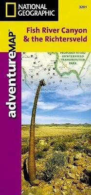
Fish River Canyon & the Richtersveld, South Africa, Namibia
Travel Maps International Adventure Map
Seiten
2012
|
Revised edition
National Geographic Maps (Verlag)
978-1-56695-166-1 (ISBN)
National Geographic Maps (Verlag)
978-1-56695-166-1 (ISBN)
- Keine Verlagsinformationen verfügbar
- Artikel merken
AdventureMaps provide global travellers with the perfect combination of detail and perspective, highlighting hundreds of points of interest and the diverse and unique destinations within the country. Each map is printed on durable synthetic paper, making them waterproof and tear-resistant. They also include the locations of cities and towns with a user-friendly index, plus a clearly marked road network complete with distances and designations for major highways, main roads and tracks and trails for those seeking to explore more remote regions.
| Erscheint lt. Verlag | 2.8.2012 |
|---|---|
| Reihe/Serie | National Geographic Adventure Maps |
| Verlagsort | Evergreen |
| Sprache | englisch |
| Maße | 108 x 235 mm |
| Gewicht | 50 g |
| Themenwelt | Reisen ► Karten / Stadtpläne / Atlanten ► Afrika |
| Reisen ► Sport- / Aktivreisen ► Afrika | |
| ISBN-10 | 1-56695-166-6 / 1566951666 |
| ISBN-13 | 978-1-56695-166-1 / 9781566951661 |
| Zustand | Neuware |
| Haben Sie eine Frage zum Produkt? |
Mehr entdecken
aus dem Bereich
aus dem Bereich
Karte (gefalzt) (2024)
Freytag-Berndt und ARTARIA (Verlag)
CHF 18,95
Karte (gefalzt) (2023)
Freytag-Berndt und ARTARIA (Verlag)
CHF 21,90
reiß- und wasserfest (world mapping project)
Karte (gefalzt) (2024)
Reise Know-How (Verlag)
CHF 17,90


