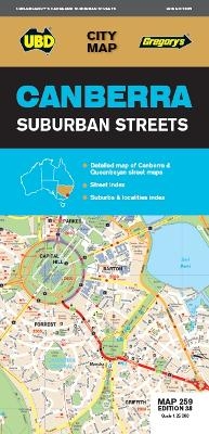
Canberra Suburban Streets Map 259 38th ed
2018
|
Thirty-eighth Edition
UBD Gregory's (Verlag)
978-0-7319-3149-1 (ISBN)
UBD Gregory's (Verlag)
978-0-7319-3149-1 (ISBN)
- Titel erscheint in neuer Auflage
- Artikel merken
Zu diesem Artikel existiert eine Nachauflage
The latest edition of the Canberra Suburban Streets map has been fully revised and updated and includes street level mapping, suburbs and a street index of Canberra, with coverage north to Casey and south to Banks. Queanbeyan is also covered on this map.
There is also detailed coverage of Capital Hill and Canberra City, Australian National University, as well as Belconnen and Woden town centres.
This handy map is an essential tool for finding you way around Canberra.
There is also detailed coverage of Capital Hill and Canberra City, Australian National University, as well as Belconnen and Woden town centres.
This handy map is an essential tool for finding you way around Canberra.
| Erscheint lt. Verlag | 8.6.2018 |
|---|---|
| Reihe/Serie | City Map |
| Zusatzinfo | N-A |
| Sprache | englisch |
| Maße | 1000 x 690 mm |
| Themenwelt | Reisen ► Karten / Stadtpläne / Atlanten |
| ISBN-10 | 0-7319-3149-1 / 0731931491 |
| ISBN-13 | 978-0-7319-3149-1 / 9780731931491 |
| Zustand | Neuware |
| Informationen gemäß Produktsicherheitsverordnung (GPSR) | |
| Haben Sie eine Frage zum Produkt? |
Mehr entdecken
aus dem Bereich
aus dem Bereich
Karte (gerollt) (2023)
Freytag-Berndt und ARTARIA (Verlag)
CHF 31,90
Karte (gefalzt) (2023)
Freytag-Berndt und ARTARIA (Verlag)
CHF 21,90
Wander-, Rad- und Freizeitkarte, 7. Auflage
Karte (gefalzt) (2023)
Pietruska (Verlag)
CHF 16,90


