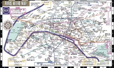
Streetwise Paris Metro Map - Laminated Metro Map of Paris, France
City Plans
Seiten
2018
Michelin Editions des Voyages (Verlag)
978-2-06-723010-1 (ISBN)
Michelin Editions des Voyages (Verlag)
978-2-06-723010-1 (ISBN)
- Titel wird nachgedruckt
- Portofrei ab CHF 40
- Auch auf Rechnung
- Artikel merken
Michelin City Plans come in practical formats, paper, laminated and accordian folds. Suited for tourist use and with clear precise mapping. Starting at 1/8000 scale and upwards
REVISED 2018
Streetwise Paris Metro Map is a laminated Paris Metro Map which conveniently folds to a pocket & wallet size metro map for travel.
Coverage includes:
Paris Metro Map with RER
Paris Metro index
Dimensions: 2.8" x 5" folded, 5" x 8.5" unfolded
The STREETWISE Paris Metro Map puts the entire Paris, France metro and RER system into the palm of your hand. Travel around Paris quickly and inexpensively on one of the world's greatest subway systems. The front of the map has the entire system neatly diagrammed and color coded so you can easily spot either where you are or where you're going. All stations are indexed on the reverse side so you can quickly look up and find your desired station location. Folded into thirds and then in half, the map is not larger than a credit card so it's conveniently sized to fit in your pants pocket or purse. This metro map of Paris is also laminated for durability and accordion folding for effortless use.
To enhance your visit to Paris, check out the Michelin Green Guide Paris which details sites and attractions using the famed Michelin star-rating system so you can prioritize your trip based on your time and interest. For a selection of the best restaurants and hotels, buy the red MICHELIN Guide Main Cities of Europe or MICHELIN Guide Paris ses environs (French only). To plan your trip to and from Paris, use Michelin France Road and Tourist Map No. 721.
| Erscheint lt. Verlag | 15.4.2018 |
|---|---|
| Verlagsort | Paris |
| Sprache | englisch |
| Maße | 72 x 220 mm |
| Gewicht | 80 g |
| Themenwelt | Reisen ► Karten / Stadtpläne / Atlanten ► Europa |
| Reiseführer ► Europa ► Frankreich | |
| ISBN-10 | 2-06-723010-7 / 2067230107 |
| ISBN-13 | 978-2-06-723010-1 / 9782067230101 |
| Zustand | Neuware |
| Haben Sie eine Frage zum Produkt? |
Mehr entdecken
aus dem Bereich
aus dem Bereich
Cityplan : Marco Polo highlights, tours d'aventure
Karte/Kartografie (2023)
MAIRDUMONT (Verlag)
CHF 13,90
Karte/Kartografie (2022)
MAIRDUMONT (Verlag)
CHF 16,90
Karte (gefalzt) (2024)
Lonely Planet Global Limited (Verlag)
CHF 13,90


