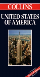
United States of America
1996
|
Revised edition
Bartholomew (Verlag)
978-0-7028-3125-6 (ISBN)
Bartholomew (Verlag)
978-0-7028-3125-6 (ISBN)
- Titel erscheint in neuer Auflage
- Artikel merken
Zu diesem Artikel existiert eine Nachauflage
Fully revised and updated, this physical reference map covers an area from British Columbia and Newfoundland to Mexico's Sierre Madre and the Bahamas - taking in 50 states on the main map at a scale of 1:5,000,000 (79 miles to one inch), with an Alaska inset 1:10,000,000 (158 miles to one inch). Relief is indicated by a system of layer colouring overlain by additional physical and communication detail - glaciers, ice fields, marshland, highways, roads, railways, canals, airports and ferry routes. International, state and provincial boundaries, state and national capitals are also featured.
| Erscheint lt. Verlag | 4.7.1996 |
|---|---|
| Reihe/Serie | Bartholomew World Travel Map S. |
| Zusatzinfo | index |
| Verlagsort | Edinburgh |
| Sprache | englisch |
| Maße | 140 x 258 mm |
| Gewicht | 101 g |
| Themenwelt | Reisen ► Karten / Stadtpläne / Atlanten ► Nord- / Mittelamerika |
| ISBN-10 | 0-7028-3125-5 / 0702831255 |
| ISBN-13 | 978-0-7028-3125-6 / 9780702831256 |
| Zustand | Neuware |
| Informationen gemäß Produktsicherheitsverordnung (GPSR) | |
| Haben Sie eine Frage zum Produkt? |
Mehr entdecken
aus dem Bereich
aus dem Bereich
Karte (gefalzt) (2024)
Freytag-Berndt und ARTARIA (Verlag)
CHF 18,95
Manhattan (Upper), Manhattan (Lower & Midtown), Financial
Karte (gefalzt) (2020)
Borch (Verlag)
CHF 13,90
Inkl. Stadtpläne, Ortsverzeichnis und Reiseinformationen
Karte (gefalzt) (2023)
Hallwag (Verlag)
CHF 19,85


