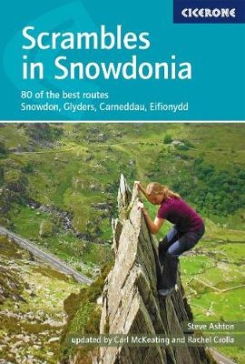
Scrambles in Snowdonia
Cicerone Press (Verlag)
978-1-85284-890-3 (ISBN)
- Titel ist leider vergriffen;
keine Neuauflage - Artikel merken
This revised edition of Steve Ashton's classic guide presents 80 scrambles in the stunning Snowdonia National Park, offering challenge, adventure and exhilaration, but also breathtaking scenery and an unparalleled opportunity to connect with the mountains of North Wales. The graded routes range from introductory traverses to demanding climbs involving technicality and exposure, recommended only for those with considerable experience, a strong head for heights and solid grounding in basic rope technique.
It is now easier than ever to explore the Carneddau, Glyders and Snowdon Group, plus the finest scrambling in Eifionydd, the Moelwyns, Rhinogs and Cadair Idris. The favourites are all here - the Snowdon Horseshoe, North Ridge of Tryfan, Bristly Ridge and Cneifion and Cyfrwy Arêtes - as well as a number of lesser-known routes, including 16 not included in the previous guide.
Photo topos illustrate the ascent routes, alongside comprehensive route description detailing the preferred line of ascent and descent options. Many routes also include ideas as to how scrambles might be combined to create longer outings, and summary information and overview statistics are provided to aid route selection. Dramatic colour photography completes the package. With advice on how to progress and stay safe, Scrambles in Snowdonia is an indispensable and comprehensive guide to enjoying the freedom and excitement of scrambling in the rugged Welsh mountains.
Steve Ashton lived in Snowdonia for 20 years, during which he wrote several climbing and walking books to the region. The best known of these is the highly influential and now classic Scrambles in Snowdonia, which was largely responsible for reviving interest in this esoteric sport. Carl McKeating and Rachel Crolla began their hiking careers in the Yorkshire Dales and the Lake District. They went on to walk and climb all over Europe, exploring all the major mountain ranges. In 2007, Rachel became the first woman to climb to the highest point of every country in Europe. The couple's resulting guidebook Europe's High Points was published by Cicerone in 2009.
Map key
Overview map
Preface
Updaters' note
Introduction
Area covered by the guide
Selection of routes
Using this guide (including explanation of grades)
Equipment
Basic rope technique
Maps
Access
Bases
Public transport
Accidents and emergencies
A final cautionary note
The Carneddau
Route 1 Southern Ridge Circuit
Pen yr Ole Wen
Route 2 Braich Ty Du Face (including Pinnacle Ridge and Porcupine Ridge)
Route 3 Broad Gully Ridge
Route 4 Craig Lloer Spur
Carnedd Dafydd
Route 5 Crib Lem (Llech Ddu Spur)
Route 6 Eastern Ridge of Black Ladders
Carnedd Llewelyn
Route 7 Craig yr Ysfa Amphitheatre
The Glyders
Route 8 Cwm Bochlwyd Horseshoe
Tryfan
Tryfan East Face
Route 9 Tryfan Bach Approach
Route 10 Bastow Buttress Variant
Route 11 Nor' Nor' Buttress Variant
Route 12 Nor' Nor' Gully
Route 13 Nor' Nor' Groove
Route 14 North Buttress Variant
Route 15 Little and North Gullies
Route 16 Pinnacle Rib Variant
Route 17 South Gully
Route 18 South Buttress
Tryfan West Face
Route 19 North Ridge
Route 20 Milestone Buttress Approach
Route 21 Milestone Gully Approach
Route 22 Milestone Continuation
Route 23 Wrinkled Tower (aka Wrinkled Slabs and Castle Chimney)
Route 24 West Face Route
Route 25 V Buttress
Route 26 V Arête
Route 27 Notch Arête
Route 28 Y Gully
Route 29 South Ridge Direct
Glyder Fach
Route 30 Bristly Ridge
Route 31 The Chasm Face
Route 32 Main Gully
Route 33 Main Gully Ridge
Route 34 East Gully Ridge
Route 35 East Gully
Route 36 Shark Buttress
Route 37 Dolmen Ridge
Glyder Fawr
Route 38 Gribin Ridge
Route 39 False Gribin
Route 40 Cneifion Arête
Route 41 Maybe Tower Rib
Route 42 Seniors' Ridge
Route 43 Seniors' Gully
Route 44 Direct Approach to Seniors' Ridge
Route 45 Idwal Staircase and Continuation
Route 46 North West Face Route (aka Idwal Buttress)
Route 47 Bryant's Gully (aka False Bryant's Gully or Nant Ettws)
Route 48 Esgair Felen Direct
Y Garn
Route 49 Devil's Kitchen and the Sheep Walk
Route 50 East Ridge
Foel Goch
Route 51 South Arête
Route 52 Needle's Eye Arête
Route 53 Yr Esgair
Carnedd y Filiast
Route 54 The Ridge (aka Atlantic Ridge)
Snowdon group
Route 55 The Snowdon Horseshoe
Crib Goch
Route 56 East Ridge
Route 57 North Ridge
Route 58 Jammed Boulder Gully
Route 59 Traverse of Crib Goch
Crib y Ddysgl (Garnedd Ugain)
Route 60 Crib y Ddysgl
Route 61 Cwm Glas Mawr Approach
Route 62 Clogwyn y Person Arête (including Parson's Nose options)
Route 63 Cwm Glas Ridge
Route 64 Llechog Buttress
Route 65 Llechog Ridge
Route 66 Eastern Terrace of Clogwyn Du'r Arddu
Route 67 Western Terrace of Clogwyn Du'r Arddu
Snowdon
Route 68 Tregalan Couloir
Route 69 Y Gribin and the East Ridge
Lliwedd
Route 70 Traverse of Lliwedd
Route 71 West Peak via Bilberry Terrace
Eifionydd
Route 72 Nantlle Ridge
Craig Cwm Silyn
Route 73 Craig Fawr Rib (aka LMH)
Mynydd Mawr
Route 74 Sentries' Ridge and Continuation
Route 75 Bear Buttress
Outlying areas
The Moelwyns
Route 76 Moel Siabod Ridge Circuit (including Daear Ddu Ridge)
The Rhinogs
Route 77 South Face of Rhinog Fawr
Route 78 South Ridge Variant, Rhinog Fach (aka Hywel Ridge)
Cadair Idris
Route 79 Cyfrwy Arête (including Table Direct option)
Conwy
Route 80 Penmaenbach Arête
Appendix A Route summary table
Appendix B Longer combination ideas
Appendix C Useful contacts
| Erscheinungsdatum | 19.08.2017 |
|---|---|
| Zusatzinfo | 10 maps, 36 photo topos and over 100 colour photographs |
| Verlagsort | Kendal |
| Sprache | englisch |
| Maße | 116 x 172 mm |
| Gewicht | 330 g |
| Themenwelt | Sachbuch/Ratgeber ► Sport |
| Reiseführer ► Europa ► Großbritannien | |
| ISBN-10 | 1-85284-890-1 / 1852848901 |
| ISBN-13 | 978-1-85284-890-3 / 9781852848903 |
| Zustand | Neuware |
| Haben Sie eine Frage zum Produkt? |
aus dem Bereich


