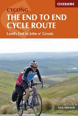
The End to End Cycle Route
Cicerone Press (Verlag)
978-1-85284-858-3 (ISBN)
- Titel ist leider vergriffen;
keine Neuauflage - Artikel merken
A guidebook describing Britain's famous Land's End to John o Groats (LEJOG) or 'End to End' cycle route, a journey of almost 1000 miles from the very tip of southwest England - Land's End - to the northernmost point of mainland Scotland - John o' Groats. Divided into 14 day stages, with each stage covering between 53 and 85 miles, the route features some of the best cycling the UK has to offer. Grid references are provided at every significant junction, along with notes on the many points of interest and the best places to stop for refreshments and repairs
The route outlined in the book is designed to take in some of the finest cycling that the UK has to offer, along the quieter A roads, B roads, lanes and cycle paths. Step-by-step route descriptions are accompanied by 1:250,000 mapping and stage profiles. There are links to GPX mapping of the route for simple GPS navigation as well as a handy equipment list, route summary table, tourist office and cycle shop listings, together with information on health and safety, training and fitness. A listing of accommodation en route is also given.
Nick Mitchell, a veteran of numerous Land's End to John o'Groats End to Ends, is a passionate long-distance cycle tourist with thousands of cycling miles to his credit. His comprehensive knowledge of the route has been built up over many years. Nick has previously cycled from Munich to Sheffield and Harwich to Bergen, topped off with a John o'Groats to Land's End. He recently cycled halfway round the coast of Britain. When he isn't in the office writing up cycling routes, Nick can be found out on the road guiding long-distance tours.
Overview map
Introduction
Things to see
Getting there
Accommodation
Getting back
Which way and when to go
Health and safety
Training fitness
What to take
Food and drink
Using this guide
The Route
Stage 1 Land's End to Fowey
Stage 2 Fowey to Moretonhampstead
Stage 3 Moretonhampstead to Street
Stage 4 Street to Monmouth
Stage 5 Monmouth to Clun
Stage 6 Clun to Runcorn
Stage 7 Runcorn to Slaidburn
Stage 8 Slaidburn to Keswick
Stage 9 Keswick to Moffat
Stage 10 Moffat to Loch Lomond
Stage 11 Loch Lomond to Glencoe
Stage 12 Glencoe to Inverness
Stage 13 Inverness to the Crask Inn
Stage 14 The Crask Inn to John o' Groats
Appendix A Route summary table
Appendix B OS maps covering the route
Appendix C Accommodation
Appendix D Tourist information
Appendix E Cycle repair shops en route
Appendix F Other useful resources
Appendix G OS grid references
| Erscheint lt. Verlag | 21.11.2019 |
|---|---|
| Zusatzinfo | 65 photos 39 maps |
| Verlagsort | Kendal |
| Sprache | englisch |
| Maße | 116 x 172 mm |
| Gewicht | 240 g |
| Themenwelt | Sachbuch/Ratgeber ► Sport ► Motor- / Rad- / Flugsport |
| Reiseführer ► Europa ► Großbritannien | |
| ISBN-10 | 1-85284-858-8 / 1852848588 |
| ISBN-13 | 978-1-85284-858-3 / 9781852848583 |
| Zustand | Neuware |
| Haben Sie eine Frage zum Produkt? |
aus dem Bereich


