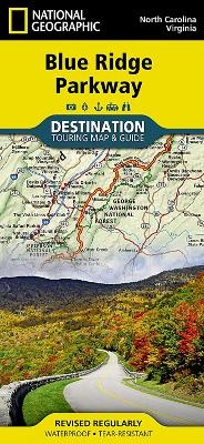
Blue Ridge Parkway, USA
Destination Map
Seiten
2015
|
2022nd ed.
National Geographic Maps (Verlag)
978-1-59775-624-2 (ISBN)
National Geographic Maps (Verlag)
978-1-59775-624-2 (ISBN)
- Titel nicht im Sortiment
- Artikel merken
Waterproof, tear-resistant travel map. The Blue Ridge Parkway is a winding route that traverses some of America's most picturesque scenery. The Parkway is America's most visited National Park unit and when combined with Skyline Drive through Shenandoah National Park, also covered in detail on this map, a travel experience of over almost 600 miles is created. The Blue Ridge Parkway starts in the south at the foot of the Great Smoky Mountains and runs along the Blue Ridge through several National Forests from North Carolina and into Virginia.
| Erscheint lt. Verlag | 23.9.2015 |
|---|---|
| Verlagsort | Evergreen |
| Sprache | englisch |
| Maße | 108 x 235 mm |
| Gewicht | 91 g |
| Themenwelt | Reisen ► Karten / Stadtpläne / Atlanten ► Nord- / Mittelamerika |
| Reiseführer ► Nord- / Mittelamerika ► USA | |
| ISBN-10 | 1-59775-624-5 / 1597756245 |
| ISBN-13 | 978-1-59775-624-2 / 9781597756242 |
| Zustand | Neuware |
| Haben Sie eine Frage zum Produkt? |
Mehr entdecken
aus dem Bereich
aus dem Bereich
Karte (gefalzt) (2024)
Michelin Editions des Voyages (Verlag)
CHF 20,55
Map
Karte (gefalzt) (2024)
Michelin Editions des Voyages (Verlag)
CHF 15,90


