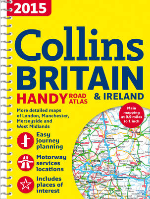
2015 Collins Handy Road Atlas Britain
Seiten
2014
|
New edition
Collins (Verlag)
978-0-00-755510-9 (ISBN)
Collins (Verlag)
978-0-00-755510-9 (ISBN)
- Titel erscheint in neuer Auflage
- Artikel merken
Zu diesem Artikel existiert eine Nachauflage
This easy-to-use, handy A5 sized road atlas with popular lie-flat spiral binding features extremely clear route planning maps of Britain and Ireland. A back up to your sat-nav or mobile phone and great for showing an overview of your journey.
The maps of Britain are at 9.9 miles to 1 inch (1:625,000) and the whole of Ireland is covered at 15.8 miles to 1 inch (1:1,000,000). There are also a selection of more detailed urban area maps at 4.5 miles to 1 inch (1:285,000) to aid route planning in these busy areas.
The atlas includes:
Road maps that focus on the main roads, motorways and settlements.
More detailed maps of London, Manchester, Merseyside and West Midlands.
Park & Ride locations (for bus and rail).
Handy distance calculator chart highlighting distances between the major towns.
Explore the world through accurate and up-to-date mapping.
| Erscheint lt. Verlag | 19.6.2014 |
|---|---|
| Verlagsort | London |
| Sprache | englisch |
| Maße | 154 x 210 mm |
| Gewicht | 130 g |
| Themenwelt | Reisen ► Karten / Stadtpläne / Atlanten ► Europa |
| ISBN-10 | 0-00-755510-5 / 0007555105 |
| ISBN-13 | 978-0-00-755510-9 / 9780007555109 |
| Zustand | Neuware |
| Haben Sie eine Frage zum Produkt? |
Mehr entdecken
aus dem Bereich
aus dem Bereich
Buch | Spiralbindung (2024)
Freytag-Berndt und ARTARIA (Verlag)
CHF 41,85


