


Canoe & Kayak Map of Britain
2012
Rivers Publishing UK (Verlag)
978-0-9550614-3-1 (ISBN)
Rivers Publishing UK (Verlag)
978-0-9550614-3-1 (ISBN)
- Titel erscheint in neuer Auflage
- Artikel merken
Zu diesem Artikel existiert eine Nachauflage
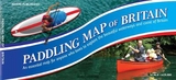
Designed to 'open the doors' to the world of canoeing and kayaking, this title also includes paddling information such as: tidal rivers and different Grades of river - Flat, classes: 1, 2, 3, 4; Navigations used by motorized craft; and especially popular canoeing trips that are highlighted in yellow.
This is a high quality map of mainland Britain which shows the huge extent of canoeing possibilities on rivers, lakes, canals and coast. It is colour-coded to show clearly the nature of these waterways. Southern England and Wales appear on one side of the B1 sheet with Scotland and the North of England on the reverse. The base map is very detailed and shows roads, towns, villages, rivers, streams, lakes and canals with this detail in pastel colours. Over this is superimposed the canoeing information in bright colours so that this stands out. Paddling information includes: tidal rivers and different Grades of river - Flat, classes: 1, 2, 3, 4; Navigations (e.g. canals) used by motorized craft; especially popular canoeing trips are highlighted in yellow; and selected coastal paddles are marked, as are artificial white water courses. This is a new map for the 21st Century - created for the two million canoeists in Britain - to inspire, excite, dream and plan that next journey. Some paddlers will buy this map for the office wall whilst for the newcomer to the sport it answers the question "where can I go paddling next?
Information panels give helpful information on access, recommended websites and guidebooks - designed to 'open the doors' to the world of canoeing and kayaking.
The author, Peter Knowles FRGS, is a world renowned expedition kayaker who has written and produced many popular and successful guide books.
| Erscheint lt. Verlag | 14.5.2012 |
|---|---|
| Zusatzinfo | full colour illustrations; full colour illustrations |
| Verlagsort | Surrey |
| Sprache | englisch |
| Maße | 245 x 115 mm |
| Themenwelt | Sachbuch/Ratgeber ► Sport ► Segeln / Tauchen / Wassersport |
| Reisen ► Karten / Stadtpläne / Atlanten ► Europa | |
| ISBN-10 | 0-9550614-3-1 / 0955061431 |
| ISBN-13 | 978-0-9550614-3-1 / 9780955061431 |
| Zustand | Neuware |
| Haben Sie eine Frage zum Produkt? |
Mehr entdecken
aus dem Bereich


aus dem Bereich
Karte/Kartografie (2024)
Delius Klasing (Verlag)
CHF 206,15
Karte/Kartografie (2024)
Delius Klasing (Verlag)
CHF 129,95