Street Map Cape Town
2009
|
14th Revised edition
Struik Publishers,South Africa (Verlag)
978-1-77026-156-3 (ISBN)
Struik Publishers,South Africa (Verlag)
978-1-77026-156-3 (ISBN)
- Titel nicht im Sortiment
- Artikel merken
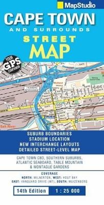
Detailed Cape Town CBD & waterfront inset map; main map in detailed 1 : 25 000 street-level scale; reserves, parks & fields; golf courses, sports fields & stadiums; retail areas & shopping malls shown; intersection layouts, route numbers & interchange names.
Detailed Cape Town CBD & waterfront inset map; main map in detailed 1 : 25 000 street-level scale; reserves, parks & fields; golf courses, sports fields & stadiums; retail areas & shopping malls shown; intersection layouts, route numbers & interchange names; places of interest, historic sites & hotels; suburb names with boundaries; schools & sporting venue locations; detailed index booklet with all street names & suburbs; industrial areas; hospital & clinic locations; police station locations; wine estates & heritage sites; traffic light positions; bird sanctuaries; detailed sport symbols for sport venues; parks and public open-areas; post office & library locations; includes latest interchange layouts; includes stadium location.
Detailed Cape Town CBD & waterfront inset map; main map in detailed 1 : 25 000 street-level scale; reserves, parks & fields; golf courses, sports fields & stadiums; retail areas & shopping malls shown; intersection layouts, route numbers & interchange names; places of interest, historic sites & hotels; suburb names with boundaries; schools & sporting venue locations; detailed index booklet with all street names & suburbs; industrial areas; hospital & clinic locations; police station locations; wine estates & heritage sites; traffic light positions; bird sanctuaries; detailed sport symbols for sport venues; parks and public open-areas; post office & library locations; includes latest interchange layouts; includes stadium location.
North: Milnerton; West: Hout Bay; East: Vanguard Drive (m7); South: Muizenberg.
| Erscheint lt. Verlag | 1.12.2009 |
|---|---|
| Sprache | englisch |
| Maße | 130 x 250 mm |
| Gewicht | 100 g |
| Themenwelt | Reisen ► Karten / Stadtpläne / Atlanten ► Afrika |
| ISBN-10 | 1-77026-156-7 / 1770261567 |
| ISBN-13 | 978-1-77026-156-3 / 9781770261563 |
| Zustand | Neuware |
| Informationen gemäß Produktsicherheitsverordnung (GPSR) | |
| Haben Sie eine Frage zum Produkt? |
Mehr entdecken
aus dem Bereich
aus dem Bereich
Karte (gefalzt) (2024)
Freytag-Berndt und ARTARIA (Verlag)
CHF 18,95
Karte (gefalzt) (2023)
Freytag-Berndt und ARTARIA (Verlag)
CHF 21,90
reiß- und wasserfest (world mapping project)
Karte (gefalzt) (2024)
Reise Know-How Peter Rump GmbH (Verlag)
CHF 17,90


