


Tokyo Travel Map
2011
|
3rd Revised edition
Tuttle Shokai Inc (Verlag)
978-4-8053-0953-7 (ISBN)
Tuttle Shokai Inc (Verlag)
978-4-8053-0953-7 (ISBN)
- Titel erscheint in neuer Auflage
- Artikel merken
Zu diesem Artikel existiert eine Nachauflage
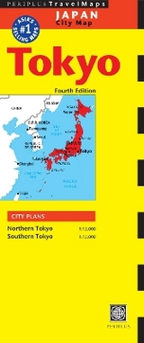
With a scale of 1:15 Th this detailed, fully indexed mapping covers northern & southern Tokyo and has been compiled using the very latest survey information. Rail network and subway system diagrams are included and there is also a comprehensive selection of tourist attractions. The unique folding system allows user to view one panel at a time.
With a scale of 1:15 Th this detailed, fully indexed mapping covers northern & southern Tokyo and has been compiled using the very latest survey information. Rail network and subway system diagrams are included and there is also a comprehensive selection of tourist attractions. The unique folding system allows user to view one panel at a time, ensuring ease of use.
With a scale of 1:15 Th this detailed, fully indexed mapping covers northern & southern Tokyo and has been compiled using the very latest survey information. Rail network and subway system diagrams are included and there is also a comprehensive selection of tourist attractions. The unique folding system allows user to view one panel at a time, ensuring ease of use.
| Erscheint lt. Verlag | 8.9.2011 |
|---|---|
| Reihe/Serie | Periplus Maps |
| Zusatzinfo | 2 City Plans |
| Verlagsort | Kanagawa |
| Sprache | englisch |
| Maße | 260 x 108 mm |
| Themenwelt | Reisen ► Karten / Stadtpläne / Atlanten ► Asien |
| ISBN-10 | 4-8053-0953-9 / 4805309539 |
| ISBN-13 | 978-4-8053-0953-7 / 9784805309537 |
| Zustand | Neuware |
| Haben Sie eine Frage zum Produkt? |
Mehr entdecken
aus dem Bereich


aus dem Bereich
Karte (gefalzt) (2024)
Freytag-Berndt und ARTARIA (Verlag)
CHF 18,95
Karte (gefalzt) (2023)
Reise Know-How (Verlag)
CHF 14,90
reiß- und wasserfest (world mapping project)
Karte (gefalzt) (2024)
Reise Know-How (Verlag)
CHF 17,90