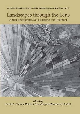
Landscapes Through the Lens
Oxbow Books (Verlag)
978-1-84217-981-9 (ISBN)
This volume presents the rich, but under-utilised and in parts inaccessible, archival historic aerial imagery, traditional photographs and those captured from satellites, for the exploration and management of cultural heritage. An unparalleled resource, for archaeologists and all with an interest in landscapes, images spanning the second half of the 20th century provide an unrivalled means of documenting and understanding change and informing the study of the past.
Case studies, written by leading experts in their fields, illustrate the applications of this imagery across a wide range of heritage issues, from prehistoric cultivation and settlement patterns, to the impact of recent landscape change. Contemporary environmental and land use issues are also dealt with, in a volume that will be of interest to archaeologists, historians, geographers and those in related disciplines.
David C Cowley, an archaeologist who has published extensively on aspects of aerial survey and photography, manages the RCAHMS aerial survey programme and is a former Chairman of the Aerial Archaeology Research Group.
1. Landscapes through the lens: an introduction (David C. Cowley, Robin A. Standring and Matthew J. Abicht)
Mapping Archaeology
2. National archives for national survey programmes: NMP and the English Heritage aerial photograph collection (Helen Winton and Pete Horne)
3. The use of aerial photographs in the study of Early Iron Age settlement patterns in Western Jutland, Denmark (Lis Helles Oleson)
4. Hidden and disappeared Mediterranean archaeo-landscapes revealed in historic aerial photographs (Anke Stoker)
5. Uses of vertical photographs for archaeological studies in parts of lowland England (Rog Palmer)
6. Old photographs and new imagery - archaeological interpretation and mapping (Alison Deegan)
7. Lost And Found: John Bradford and aerial photographs of Italy and elsewhere from the 1940s (Chris Musson and Francesca Franchin Radcliffe)
8. Rediscovering prehistoric earthworks in Ohio, USA: it all starts in the archives (Jarrod Burks)
9. Ephemeral coastal defences of the two World Wars in North East England (Cinzia Bacilieri and Roger J. C. Thomas)
10. Satellite imagery and archaeology (Martin J. F. Fowler)
Understanding Landscape Change
11. Reconstructing landscape evolution in the Lower Khuzestan plan (SW Iran): integrating imagery, historical and sedimentary perspectives (Jan Walstra, Peter Verkinderen and Vanessa M. A. Heyvaert)
12. Land use and accelerated soil erosion by water in a small catchment area on the South Downs, West Sussex, England - past and present (Robert Evans)
13. Using historic aerial photographs for measuring change on the Antarctica Peninsula (Adrian Fox, Alison Cook and Andreas Cziferszky)
14. Politics and landscape change in Poland: c.1940-2000 (Jolanta Kijowska, Andrzej Kijowski and Wlodzimierz Raczkowski)
15. Exploring rural landscapes in Sudanese Nubia (David N. Edwards)
16. The use of historical charts and photographs in ecosystem restoration: examples from the Everglades Historical Air Photo Project (Thomas J. Smith III, Ginger Tiling-Range, John Jones, Paul Nelson, Ann Foster and Karen Balentine)
Engaging with Cultural Heritage
17. Archives and aerial imagery in Jordan: rescuing the archaeology of Greater Amman from rapid urban sprawl (David Kennedy and Robert Bewley)
18. Rapid urbanization and cultural heritage management in Bahrain: reconstructing the original distribution of Bronze Age burial mounds from a 1959 aerial photograph archive (Steffen Terp Laursen)
19. Engaging diverse audiences with aerial photographs (Jane Golding)
Military Archaeology
20. Great War aerial photographs: The Imperial War Museum's Box Collection (Birger Stichelbaut, Wouter Gheyle and Jean Bourgeois)
21. Italian aerial photographic archives: holdings and case studies (Giuseppe Ceraudo and Elizabeth J. Shepherd)
22. US7GR LOC 349 3041 - one Saturday afternoon on the Home Front (Cathy Stoertz)
23. World War II aerial photographs for military archaeology in Scotland (David R. Easton
24. Using wartime aerial photographs to locate lost grave sites (Matthew J. Abicht)
25. The Holocaust from above: Auschwitz imagery and beyond (Daniel Uziel)
26. GX of the Solovetskiye Islands, Russia: using World War II Luftwaffe aerial photographs (Waclaw Godziemba-Maliszewski)
27. The Skrunda Hen Houses: a case study in Cold War satellite archaeology (Martin J. F. Fowler)
| Erscheint lt. Verlag | 11.11.2010 |
|---|---|
| Zusatzinfo | b/w and col illus |
| Verlagsort | Oxford |
| Sprache | englisch |
| Themenwelt | Kunst / Musik / Theater ► Fotokunst |
| Geisteswissenschaften ► Archäologie | |
| ISBN-10 | 1-84217-981-0 / 1842179810 |
| ISBN-13 | 978-1-84217-981-9 / 9781842179819 |
| Zustand | Neuware |
| Haben Sie eine Frage zum Produkt? |
aus dem Bereich


