Through the Spanish Pyrenees: GR11
Cicerone Press (Verlag)
978-1-85284-524-7 (ISBN)
- Titel ist leider vergriffen;
keine Neuauflage - Artikel merken
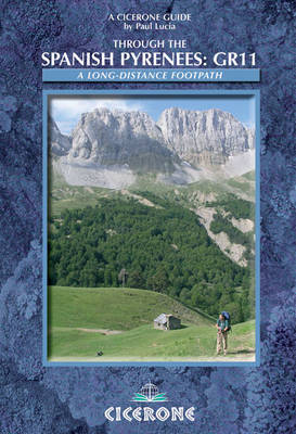
Walking the GR11 (La Senda) trek, as described in this guidebook, takes you through Spain's Pyrenees from the Atlantic at Iruns to the Mediterranean at Calaques, and is one of the world's great trekking routes. The Spanish Pyrenees present a wonderland to the holidaymaker, whether backpacker, botanist, canoeist, cyclist, entomologist, ornithologist, mountain biker, skier, walker or simply anyone with a love of mountain scenery. In recent years the mountain organisations and authorities in the administrative districts of Guipuzxoa, Navarra, Aragón, Andorra and Cataluña have got together with local villagers to arrange the waymarking of a coast to coast (Atlantic to Mediterranean) long-distance footpath through the Pyrenees on the Spanish side. Designated the Gran Recorrido 11, it mirrors the French counterpart, the GR10. This has opened up miles of waymarked footpaths and tracks in an ever-changing environment, often in remote and high area, to numerous enthusiastic walkers of many nationalities but those seeking solitude will also not be disappointed. The GR11 is now a truly high quality, high-level mountain trail, a combination of spectacular high peaks, glistening tarns, deep green valleys and expanses of wild beauty as yet unseen by many visitors in addition to a moderate climate and easy access. This fourth edition includes revised maps, tables and profiles, accommodation details and route descriptions and will meet the needs of walkers on both day trips and longer expeditions.
Paul Lucia explored the Pyrenees for many years and became an acknowledged expert on the region. 'Through the Spanish Pyrenees:GR11' was first published in 1996, the fruit of many happy research trips, and has been meticulously updated ever since. Paul passed away on 6th July 2007, a few weeks after visiting the Pyrenees for the last time.
Foreword
Preface to the fourth edition
Introduction
Access
Geography
GR10 and GR11 compared
Equipment
Maps
Mountain huts
Mountain rescue
Insurance
Telephone codes
Waymarking and Navigation
Weather
Wild camping
Water
Wildlife
Notes on using this guide
Sketch maps
Metric conversion table
GR11 facilities list
The Route
Day 1: Cabo Higuer - Vera de Bidasoa
Day 2: Vera de Bidasoa - Elizondo
Day 3: Elizondo - Puerto de Urkiaga
Day 4: Puerto de Urkiaga - Burguete
Day 5: Burguete - Fábrica de Orbaiceta
Day 6: Fábrica de Orbaiceta - Casas de Irati
Day 7: Casas de Irati - Ochagavia
Day 8: Ochagavia - Isaba
Day 9: Isaba - Zuriza
Day 10: Zuriza - La Mina
Day 11: La Mina - Candanchú
Day 12: Candanchú - Sallent de Gállego
Day 13: Sallent de Gállego - Refugio de Respomuso
Day 14 Refugio de Respomuso - Baños de Panticosa
Day 15: Baños de Panticosa - San Nicolás de Bujaruelo
Day 16: Bujaruelo - Refugio de Góriz
Day 17: Refugio de Góriz - Circo de Pineta
Day 18: Circo de Pineta - Parzán
Day 19: Parzán - Biadós
Day 20: Biadós - Refugio d'Estós
Day 21: Estós - Refugio del Puen de Corones
Day 22: Puen de Corones - Hospital de Viella
Day 23: Hospital de Viella - Refugi dera Restanca
Day 24: Refugi dera Restanca - Refugi de Colomers
Day 25: Refugio de Colomers - Espot
Day 26: Espot - La Guingueta
Day 27 La Guingueta - Estaon
Day 28: Estaon - Tavascan
Day 29: Tavascan - àreu
Day 30: àreu - Refugi de Baiau (J.M. Montfort)
Day 31: Refugi de Baiau - Arans
Day 32: Arans - Encamp
Day 33: Encamp - Cabana dels Esparvers
Day 34: Cabana dels Esparvers - Refugi de Malniu
Day 35: Refugi de Malniu - Puigcerdà
Day 36: Puigcerdà - Planoles
Day 37: Planoles - Núria
Day 38: Núria - Setcases
Day 39: Setcases - Beget
Day 40: Beget - Sant Aniol d'Aguja
Day 41: Sant Aniol d'Aguja - Albanyà
Day 42: Albanyà - La Vajol
Day 43: La Vajol - Requesens
Day 44: Requesens - St. Quirze de Colera
Day 45: St. Quirze de Colera - El Port de la Selva
Day 46: El Port de la Selva - Cap de Creus
GR11 variants
Appendices
Glossary
Bibliography
Route Summary
| Erscheint lt. Verlag | 29.2.2008 |
|---|---|
| Zusatzinfo | 100 colour photos, 50 profiles and 50 maps |
| Verlagsort | Kendal |
| Sprache | englisch |
| Maße | 116 x 172 mm |
| Gewicht | 320 g |
| Themenwelt | Sachbuch/Ratgeber ► Sport |
| Reiseführer ► Europa ► Spanien | |
| ISBN-10 | 1-85284-524-4 / 1852845244 |
| ISBN-13 | 978-1-85284-524-7 / 9781852845247 |
| Zustand | Neuware |
| Haben Sie eine Frage zum Produkt? |
aus dem Bereich


