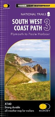
South West Coast Path 3
Plymouth to Poole Harbour
Seiten
2024
Harvey Map Services Ltd (Verlag)
978-1-85137-683-4 (ISBN)
Harvey Map Services Ltd (Verlag)
978-1-85137-683-4 (ISBN)
The South West Coast path is a 1014km (630mile) long distance path and the longest National Trail in England.
The path stretches from Minehead in Somerset to Poole in Dorset.
- This updated Trail Map covers the third and final section of the South West Coast Path from Plymouth to Poole Harbour which is 339km (211 miles).
- Includes the Jurassic Coast World Heritage Site and Durdle Door, the famous sea arch in Dorset.
- The entire route on 3 sheets. This is map 3 of 3, a good two weeks? walking on one map.
- The XT40 is based on original HARVEY mapping with all the detail a walker would expect on a map at 1:40,000 scale.
- Clear and easy to read mapping which is uncluttered by information irrelevant to the walker.
- Printed on tough, light and 100% waterproof paper, less than half the weight of a laminated map.
- Shows facilities and services along the route
| Erscheint lt. Verlag | 26.3.2024 |
|---|---|
| Reihe/Serie | Trail map |
| Verlagsort | Perthshire |
| Sprache | englisch |
| Maße | 115 x 245 mm |
| Gewicht | 60 g |
| Themenwelt | Reisen ► Karten / Stadtpläne / Atlanten |
| ISBN-10 | 1-85137-683-6 / 1851376836 |
| ISBN-13 | 978-1-85137-683-4 / 9781851376834 |
| Zustand | Neuware |
| Haben Sie eine Frage zum Produkt? |
Mehr entdecken
aus dem Bereich
aus dem Bereich
Karte/Kartografie (2024)
BVA BikeMedia (Verlag)
CHF 25,90
Karte (gefalzt) (2023)
Freytag-Berndt und ARTARIA (Verlag)
CHF 21,90
Karte (gerollt) (2023)
Freytag-Berndt und ARTARIA (Verlag)
CHF 31,90


