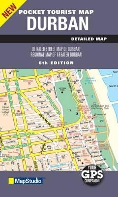
Pocket Tourist Map Durban
2010
|
6th edition
Struik Publishers,South Africa (Verlag)
978-1-77026-234-8 (ISBN)
Struik Publishers,South Africa (Verlag)
978-1-77026-234-8 (ISBN)
- Titel nicht im Sortiment
- Artikel merken
This updated edition pocket tourist map of Durban includes key tourist areas and streetplan with new street names and lists of old street names. The street plan includes main and minor roads, retail and industrial areas, traffic light positions, hotels and accommodation, tourist information, theatres and cinemas, shopping malls, parking, one-way streets, sport and recreation areas, railways and stations, suburb names and an index of street names. Coverage includes a detailed street plan map of Durban at 1: 12 500 scale. A detailed Durban regions and surrounds map at 1 : 100 000 scale includes La Mercy, uMlanga, Inanda, KwaMashu, Kloof, Mariannhill, Queensburgh, The Bluff, uMlazi, aManzimtoti and Illovo. The maps shows suburbs and main routes, shopping malls and airports, industrial areas, hospitals, parks and reserves.
| Erscheint lt. Verlag | 1.8.2010 |
|---|---|
| Sprache | englisch |
| Maße | 100 x 170 mm |
| Gewicht | 40 g |
| Themenwelt | Reisen ► Karten / Stadtpläne / Atlanten ► Afrika |
| ISBN-10 | 1-77026-234-2 / 1770262342 |
| ISBN-13 | 978-1-77026-234-8 / 9781770262348 |
| Zustand | Neuware |
| Haben Sie eine Frage zum Produkt? |
Mehr entdecken
aus dem Bereich
aus dem Bereich
Karte (gefalzt) (2024)
Freytag-Berndt und ARTARIA (Verlag)
CHF 18,95
Karte (gefalzt) (2023)
Freytag-Berndt und ARTARIA (Verlag)
CHF 21,90
reiß- und wasserfest (world mapping project)
Karte (gefalzt) (2024)
Reise Know-How (Verlag)
CHF 17,90


