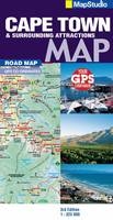
Road map Cape Town & surrounds
2010
|
3rd ed
Struik Publishers,South Africa (Verlag)
978-1-77026-107-5 (ISBN)
Struik Publishers,South Africa (Verlag)
978-1-77026-107-5 (ISBN)
- Titel wird leider nicht erscheinen
- Artikel merken
Detailed map at 1 : 325 000 scale South Western Cape, Overberg & Winelands; detailed map for scenic drives of the region; index of place names & big 6 attractions; index of wine estates. Places of interest: tourist sites; historical sites; lighthouses; wine estates + wineries; swimming beaches; dive sites; shipwreck sites; whale watching sites; birding sites; farm stalls; 4x4 trails & hiking trails; memorials; parks, reserves & nature areas; hotels & caravan parks; tourist friendly text on top sites with historic info; topography indicating heights; listings of regional activities. GPS co-ordinates: All the back roads + gravel roads you need. colour photo's of main sites. Comprehensive contact info for regions.
Cape Town; West Coast; Cape Winelands; Stellenbosch; Franschhoek; Paarl; Wellington; Robertson; Hermanus; Breede River Valley; Overberg; Route 43; Boland; Hex River Valley; Swartland; Whale Route; Route 62. Street maps - 1 : 20 000; Stellenbosch - Winelands; Franschhoek - Winelands; Paarl - Winelands; Wellington - Winelands; Hermanus - The Whale Route; Somerset West - The Whale Route; Strand - The Whale Route; Montagu - The Heart of Route 62; Robertson - The Heart of Route 62; Worcester - The Breede River Valley; Ceres - The Breede River Valley; Tulbagh - The Breede River Valley; Cape Town CBD - 1 : 17 500.
| Erscheint lt. Verlag | 1.1.2010 |
|---|---|
| Sprache | englisch |
| Maße | 130 x 250 mm |
| Gewicht | 100 g |
| Themenwelt | Reisen ► Karten / Stadtpläne / Atlanten ► Afrika |
| ISBN-10 | 1-77026-107-9 / 1770261079 |
| ISBN-13 | 978-1-77026-107-5 / 9781770261075 |
| Zustand | Neuware |
| Haben Sie eine Frage zum Produkt? |
Mehr entdecken
aus dem Bereich
aus dem Bereich
Karte (gefalzt) (2024)
Freytag-Berndt und ARTARIA (Verlag)
CHF 18,95
Karte (gefalzt) (2023)
Freytag-Berndt und ARTARIA (Verlag)
CHF 21,90
reiß- und wasserfest (world mapping project)
Karte (gefalzt) (2024)
Reise Know-How (Verlag)
CHF 17,90


