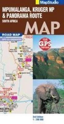
Road Map Mpumalanga, Kruger National Park & Panorama Route
2009
|
3rd Revised edition
Struik Publishers,South Africa (Verlag)
978-1-77026-090-0 (ISBN)
Struik Publishers,South Africa (Verlag)
978-1-77026-090-0 (ISBN)
- Titel ist leider vergriffen;
keine Neuauflage - Artikel merken
Mpumalanga Lowveld Region, Kruger National Park; driving route around the region; full-colour images & informative text; simple easy-to-use map.
Mpumalanga Lowveld Region, Kruger National Park; driving route around the region; full-colour images & informative text; simple easy-to-use map; detailed street maps & site maps with text & photographs of: Pilgrims rest; Lydenburg; Dullstroom; Belfast; Machadodorp; Sudwala Caves; Sabie; Waterval Boven; Hazyview; Nelspruit; Barberton; Kruger National Park, including the Limpopo (Northern) Park; Kruger National Park Camp Layouts. The Waterfall Route in detail; detailed hiking trails, 4X4 trails; Lydenberg and surrounds; Dullsroom & surrounds; Blyde River Canyon Region in detail, with sites, trails & lookout points; Fly fishing accommodation and sites; easy-to-use map symbols: Hotels, Lodges, Rest Camps, Campsites, Concession; Lodges, Bush Camps, Private Rest Camps, Caravan Facilities, Luxury Tented; Camps, Caves, Places of interest, Lookout Points, Waterholes, Hides, Hiking, Trekking, Walking & Fly-Fishing informative text.
Mpumalanga Lowveld Region, Kruger National Park; driving route around the region; full-colour images & informative text; simple easy-to-use map; detailed street maps & site maps with text & photographs of: Pilgrims rest; Lydenburg; Dullstroom; Belfast; Machadodorp; Sudwala Caves; Sabie; Waterval Boven; Hazyview; Nelspruit; Barberton; Kruger National Park, including the Limpopo (Northern) Park; Kruger National Park Camp Layouts. The Waterfall Route in detail; detailed hiking trails, 4X4 trails; Lydenberg and surrounds; Dullsroom & surrounds; Blyde River Canyon Region in detail, with sites, trails & lookout points; Fly fishing accommodation and sites; easy-to-use map symbols: Hotels, Lodges, Rest Camps, Campsites, Concession; Lodges, Bush Camps, Private Rest Camps, Caravan Facilities, Luxury Tented; Camps, Caves, Places of interest, Lookout Points, Waterholes, Hides, Hiking, Trekking, Walking & Fly-Fishing informative text.
| Erscheint lt. Verlag | 1.9.2009 |
|---|---|
| Sprache | englisch |
| Maße | 130 x 250 mm |
| Gewicht | 98 g |
| Themenwelt | Reisen ► Karten / Stadtpläne / Atlanten ► Afrika |
| ISBN-10 | 1-77026-090-0 / 1770260900 |
| ISBN-13 | 978-1-77026-090-0 / 9781770260900 |
| Zustand | Neuware |
| Haben Sie eine Frage zum Produkt? |
Mehr entdecken
aus dem Bereich
aus dem Bereich
Karte (gefalzt) (2024)
Freytag-Berndt und ARTARIA (Verlag)
CHF 18,95
Karte (gefalzt) (2023)
Freytag-Berndt und ARTARIA (Verlag)
CHF 21,90
reiß- und wasserfest (world mapping project)
Karte (gefalzt) (2024)
Reise Know-How (Verlag)
CHF 17,90


