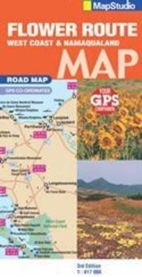
Road Map Flower Route
2009
|
3rd Revised edition
Struik Publishers,South Africa (Verlag)
978-1-77026-086-3 (ISBN)
Struik Publishers,South Africa (Verlag)
978-1-77026-086-3 (ISBN)
- Titel ist leider vergriffen;
keine Neuauflage - Artikel merken
Detailed exploring map of flower route region at 1 : 417 000 scale; information boxes on activities and facilities available; over 45 detailed flower identification photos. Includes: entire route from Cape Town to the Namibian border; Richtersveld national park map; Namaqua national park map; West Coast national park map; new Vanrynsdorp street plan; Cederberg map; Malmesbury; Lambert's bay; Citrusdal; Clanwilliam; Springbok; a double-sided information map supporting responsible land use & promoting tourism; attractions and contacts; route planner from the N7 to route 27 and everything in between.
| Erscheint lt. Verlag | 1.7.2009 |
|---|---|
| Sprache | englisch |
| Maße | 130 x 250 mm |
| Gewicht | 100 g |
| Themenwelt | Reisen ► Karten / Stadtpläne / Atlanten ► Afrika |
| ISBN-10 | 1-77026-086-2 / 1770260862 |
| ISBN-13 | 978-1-77026-086-3 / 9781770260863 |
| Zustand | Neuware |
| Haben Sie eine Frage zum Produkt? |
Mehr entdecken
aus dem Bereich
aus dem Bereich
Karte (gefalzt) (2024)
Freytag-Berndt und ARTARIA (Verlag)
CHF 18,95
Karte (gefalzt) (2023)
Freytag-Berndt und ARTARIA (Verlag)
CHF 21,90
reiß- und wasserfest (world mapping project)
Karte (gefalzt) (2024)
Reise Know-How (Verlag)
CHF 17,90


